
Jackson Park
by John Lindfors
Overview
- County: Henderson
- Habitats: Mixed deciduous/pine forest, riparian, streams and drainage, open unmowed meadow, and athletic fields.
- Key birds: Winter: Brown Creeper Winter Wren,Hermit Thrush, Rusty Blackbird, Swamp Sparrow, and Great Horned Owl. Year-round: Red-shouldered Hawk and common woodpeckers. Migration: Thirty-six of the thirty-nine warblers seen east of the Mississippi and other neotropical migrants.
- Best times to bird: March 20–May 31st and August 15–October 5th.
Description
Jackson Park is located on the east side of Hendersonville, NC, twenty miles south of Asheville, NC.
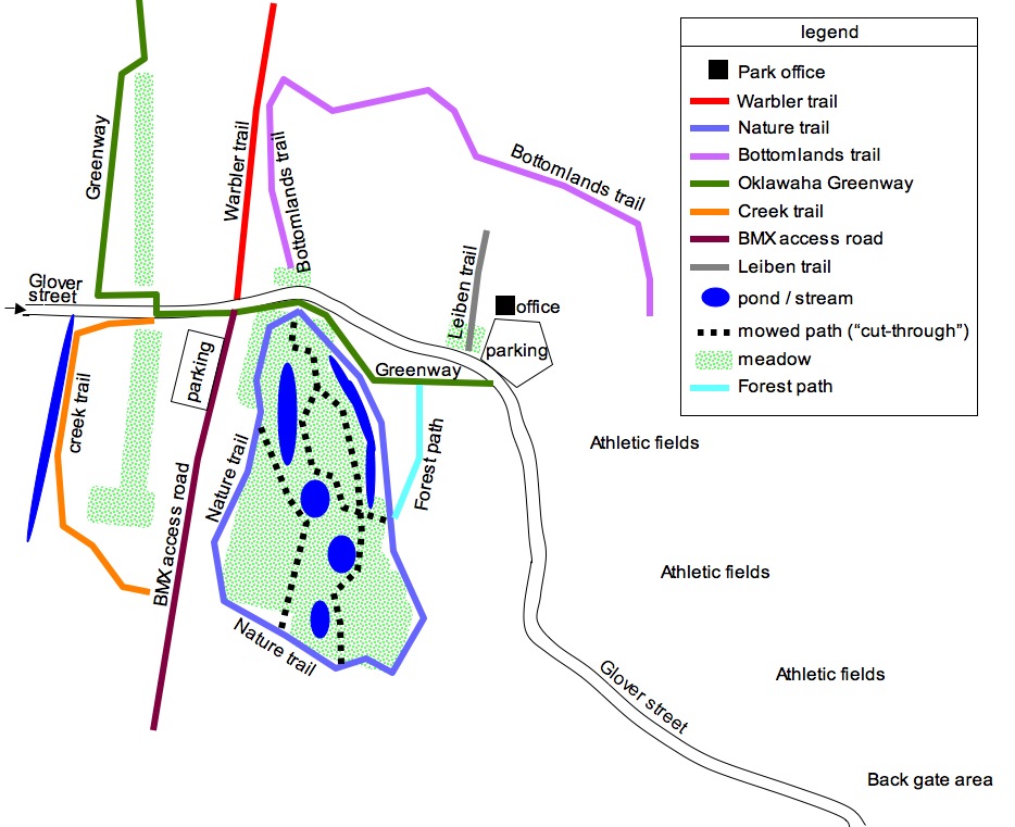 |
| Trails at Jackson Park. CLICK TO ZOOM. |
NATURE TRAIL: If you have parked in the main parking lot at the headquarters and walk down the slope on the paved exercise path with a center line on it you are walking on the Oklawaha Greenway. Walking under the pines you come to another older paved walk known as the NATURE TRAIL. (A stone wall meeting the Nature Trail will be at your left.) This 3/4 mile loop is the best place to find warblers in season.
Walk toward the paved main road. You will come to a paved path close to a wide stream full of arrowhead etc. Deciduous trees line the path and only in one or two places can you see the stream. Walking counterclockwise on the Nature Trail you will come to a metal pedestrian bridge. Walk past it 1/10 of a mile until you come to a park bench. Behind the bench is a mowed path known as the “CUT-THROUGH.” Stay on the paved Nature Trail and go into the shaded wood walk around the curve and when you come to the mowed trail you have come to the south end of the Cut-Through. Walk north on the Cut-Through and come back to the bench and then retrace your steps to the metal bridge.
BMX ACCESS RD & WARBLER TRAIL: When you cross the metal bridge you are at the north end of the BMX access road. Turn right (North) and cross the main park road (Glover St.) and step over the chain on to the WARBLER TRAIL. It is about 3/4 of a mile in length. On the right is a drainage ditch and to your left is a frequently wet woods filled with River Birch.
BOTTOMLAND TRAIL: Time permitting, when you finish the Warbler Trail walk a few yards on the main park road back toward the headquarters building to the lawn on the north side of the road before it rises to meet the entrance of the Park Headquarters Parking Lot.
Walk north on the Bottomland Trail. On the left should be warblers, and on the right should be thrushes and upland species of birds. Walk 1/10 of a mile to a right turn and walk till the path forks. The right fork is quite wide and goes up toward the Headquarters Building. Take the left fork to stay with the stream on your left. Rhododendrons will be on your right as you ascend and come to were the stream empties into a larger stream. Curve round and the stream will widen before you into a flooded wood. You will come to a foot path, if you have no more time, take the path up the hill. It will bring you up to the headquarters building from the east side. Otherwise stay on the Bottomland Trail as it, once again, parallels the stream till it comes to another flooded wood area where the path turn south and brings you a large lawn with a stage or amphitheater there. If you walk up the hill you will come back to the main headquarters parking area.
BACK GATE: The easternmost section of the park, known as the “Back Gate” has four ball fields. The road that goes around the ball fields follows a stream known as the “Bat Fork.” on the north side and “Hope Creek” on the east side. Hope Creek empties into Bat Fork.
ATHLETIC FIELDS: The section west of the ball fields has agricultural extension offices on the south of the main road and a group picnic area west of it. On the north side of the main road is a large parking lot, playground and tennis fields beyond. On the north side is an open lawn area that is used as soccer fields. Continuing on the main paved road (on some maps called Glover St.), we see the pine/mixed wood picnic area on the left and as we make the turn down and west we come to the large main parking area of the Jackson Park Headquarters.
HEADQUARTERS HILL AREA: Birders who park at the main headquarters parking area often walk around the lawn of the headquarters building. They can check the kiosk for a map of the park and check the trees for birds. To the west of the headquarters lawn is 1/4 mile loop trail. The upper entrance is the “Lieben's Loop” trail. At its terminus there is a sign calling it “Jason's Romp.” It has provided happy birders with nesting Great Horned Owl, American Woodcock, migrating Summer Tanagers at times. But often it can be unproductive.
Directions
Take Interstate 26 to Exit 49. The park is located 1 AND 1/5 miles west as you drive past the major intersection with the WKRP Radio advertising sign on your right and start going up hill make a left at the light on Harris St. Go two short blocks to a “T” which is 4th Ave. Turn left go down the slope to the western entrance of Jackson Park. The road crosses Mud Creek and goes under a utility line. The first road coming from the right is the BMX access road. On your left, across from the BMX access road, is the entrance to the WARBLER TRAIL. If you don't have a lot of time, park on the BMX access road just before the metal pedestrian bridge. Otherwise stay on the paved road and drive 2/10ths of a mile up the slope turn left and park in the large parking lot for the Park Headquarters building.
Maps
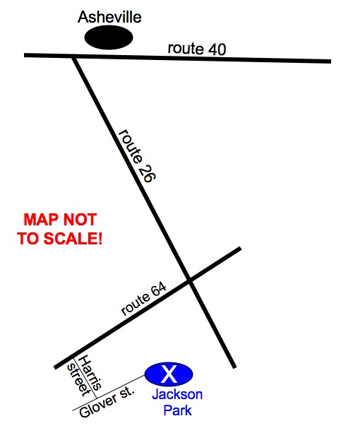 |
| Map to Jackson Park from Asheville. CLICK TO ZOOM. |
Birding Highlights
Spring: Check the Nature Trail, The Cut-Through, and the Warbler Trail for warblers, flycatchers, tanagers, and Rose-breasted Grosbeak. In late March try for Louisiana Waterthrush. Experienced birders often come from May 10th to the 20th after the Spring Migration has really ldquo;finished” in quest of Mourning Warbler and Connecticut Warbler. Summer: In late July check the ballfield light poles for Purple Martin. Fall: Go to the same places mentioned in the Spring section above. You will see many Chestnut-sided Warblers, and American Redstarts. But Golden-winged Warblers and Blue-winged Warblers are possible. In early September check the trees for a Yellow-bellied Flycatcher (beware of yellowish Acadian's with their white, not yellow throats.) In mid-September kettles of Broad-winged Hawks will be circling above and you can expect to find Philadelphia Vireo. Winter: This is the best time to check for Winter Wren and Swamp Sparrows. On December 7th (Pearl Harbor Day) of 2001, Ron Selvey, Harvey Neal and John Lindfors found a rare immature Northern Goshawk flying over the Nature Trail on the east side. Late spring can bring rarities like Dickcissel to a meadow at the Back Gate.
Historical Information
Jackson Park was “discovered” by Wayne Forsythe back in 1985 when a visiting birder wanted to check out a local park. No other birder has seen more really exciting and rare birds than Wayne. All birders of Henderson County owe Wayne a debt of gratitude for putting Jackson Park and Hooper Lane “on the map.”
General Information
Restroom and picnic facilities, water fountains, are available in the park. Restaurants and other facilities are located at exits to the east and west of the park along Four Season Boulevard. There are restaurants east of Interstate 26 at the large Walmart mall and a Golden Corral on the south side of Four Seasons Blvd (Its name changes to Chimney Rock Rd.)